Tur Matahari Terbit Merapi: Pengalaman Jujur Seorang Pemula tentang Apa yang Harus Diharapkan
Nobody tells you about the cold. You read about the jeep, the lava fields, the crater views at dawn. You…

Before you board the jeep, before you step into the Museum Sisa Hartaku and see the melted motorbikes, before your guide points to the Bunker Kaliadem and tells you what happened there, it helps to understand what you’re actually looking at.
The 2010 Merapi eruption was the most powerful the volcano had produced in over a century. What it left behind is not just a landscape, but a record of one of the most significant natural disasters in modern Indonesian history. The jeep tour takes you through that record. This is the story behind it.
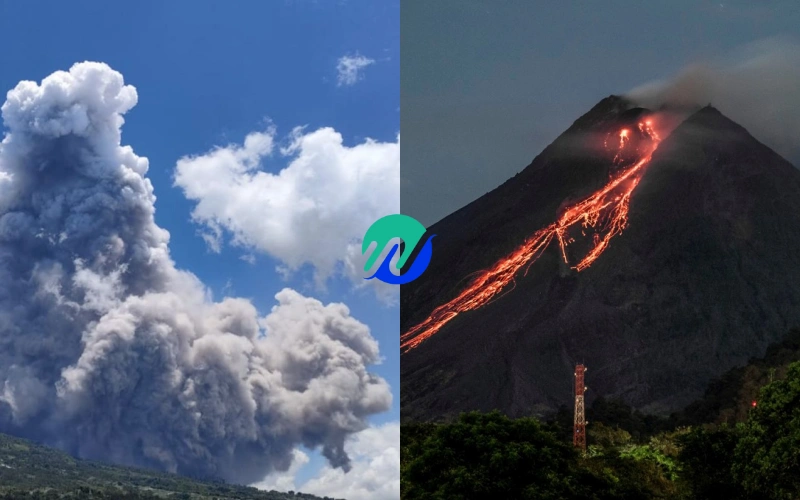
Merapi is a stratovolcano, a steep-sided cone built up over thousands of years from alternating layers of hardened lava and volcanic ash. It sits on a destructive plate boundary where the Indo-Australian plate is being forced beneath the Eurasian plate, generating the heat and pressure that drives volcanic activity across the Indonesian archipelago.
It is one of the most active volcanoes on Earth and has been erupting continuously in some form since at least the 16th century.
Significant eruptions occurred in 1872, 1930, 1994, and 2006 before the catastrophic 2010 event. The fertile volcanic soil it produces has attracted dense agricultural settlement on its slopes for centuries, which is why every major eruption carries a human cost.
At the time of the 2010 eruption, an estimated 400,000 people lived within the potential impact zone.
Seismic monitoring detected increasing activity at Merapi in mid-September 2010. By October 25, the Indonesian government raised the alert to its highest level and began issuing evacuation orders for communities within a 10-kilometer radius of the summit.
The eruptions began on October 26. Over the following five weeks, Merapi erupted repeatedly, each event pushing further down the mountain.
Ash plumes reached 18 kilometers into the atmosphere. Pyroclastic flows, superheated avalanches of gas, ash, and volcanic rock moving at up to 100 kilometers per hour, traveled as far as 15 kilometers from the crater. Volcanic ash fell on communities up to 480 kilometers away.
By the time the eruptions subsided on November 30, 353 people had been killed, the majority by pyroclastic flows. More than 2,000 homes were destroyed.
Nearly 350,000 people had been evacuated from the affected zones, with many spending weeks in emergency shelters. Economic losses were estimated at around 600 million US dollars.
The 2010 eruption was classified as a 4 on the Volcanic Explosivity Index, making it the largest Merapi eruption since 1872.
Among those who died was Mbah Maridjan, the official spiritual gatekeeper of Mount Merapi, a title and role appointed by the Sultan of Yogyakarta.
His responsibility was to maintain the relationship between the mountain’s spiritual guardians and the communities living on its slopes, a tradition rooted in Javanese cosmology that predates modern volcanology.
When evacuation orders were issued, Mbah Maridjan refused to leave. He had refused similar orders during the 2006 eruption and survived. In 2010, he did not. His body was found in a position of prayer near his home in Kinahrejo village, on the mountain’s southern slope.
His decision was widely reported and generated significant debate in Indonesia about the relationship between traditional belief systems and modern disaster management. To many Javanese, he died fulfilling his sacred duty. To others, his refusal contributed to a number of his neighbors staying behind as well.
His former home is now preserved as a memorial and is a stop on the longer Merapi jeep tour routes. The village of Kinahrejo was entirely buried in the 2010 eruption.
Bunker Kaliadem was built into the hillside on Merapi’s southern slope specifically to protect people who could not evacuate in time. During the 2006 eruption, it had functioned as intended.
In 2010, two men sheltered inside as the pyroclastic flows descended. The flows were larger and faster than the 2006 event, and the temperatures they carried, several hundred degrees Celsius, were beyond what the structure was designed to withstand. Both men died inside.
The bunker is still there, open to visitors on the jeep tour. The interior is scarred by heat. It is a quiet, affecting stop, and the weight of it comes entirely from knowing the history.
In the aftermath of the eruption, the hazard exclusion zone around Merapi was permanently expanded from a 10-kilometer to a 20-kilometer radius in the highest-risk areas. Over 2,500 residents were relocated to permanent homes built outside the new exclusion zones.
Volcanic monitoring was significantly upgraded, with new sensor networks providing real-time data to the national volcanology agency BPPTKG. Evacuation infrastructure, including road access and community warning systems, was rebuilt and improved.
The jeep tour routes that operate today are carefully planned to stay within officially designated safe zones, well below the exclusion area. Reputable operators follow BPPTKG updates and will reschedule tours if activity levels change. This is standard practice, not an exception.
The landscape the Merapi jeep tour passes through is not just scenic volcanic terrain. It is the physical record of what happened in 2010, preserved in hardened lava flows, reshaped riverbeds, and the ruins of communities that were buried and then slowly rebuilt. The museum, the bunker, and the viewpoints are not incidental stops on an adventure tour. They are memorials.
Understanding the 2010 eruption before you go doesn’t diminish the experience. It makes every stop more coherent, and the human stories behind the landscape more visible.
Wahyu Travel Indonesia offers Merapi jeep tours with English-speaking driver-guides who know this history firsthand and can bring the context to life throughout the route. See the Merapi 4×4 Jeep Lava Tour and the Merapi Sunrise Jeep Tour for tour options from Yogyakarta.